|
| It's going to rain. Nicholas (Page 1/1) |

|
maryjane
|
SEP 13, 09:21 PM
|
|
Getting closer it looks like and the models have (mostly) come together for a better consensus. Winds currently at 70mph.
Latest 'says' ashore on mid Texas coast near Palacios, up I-59 to just north of Houston and hang a hard right thru East Tx, La and on into Mississippi.
(nothing is for certain tho.)
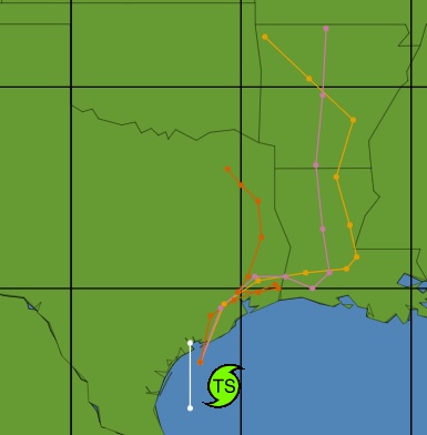
FORECAST POSITIONS AND MAX WINDS
INIT 13/2100Z 27.4N 96.4W 55 KT 65 MPH
12H 14/0600Z 28.7N 96.1W 60 KT 70 MPH...ON THE COAST-Near Palacios Tx
24H 14/1800Z 29.9N 95.3W 40 KT 45 MPH...INLAND-NE Houston inside bltwy8
36H 15/0600Z 30.4N 94.4W 30 KT 35 MPH...INLAND-Near Honey Island/Kountz Tx
48H 15/1800Z 30.9N 92.9W 25 KT 30 MPH...INLAND-25 mi ENE of Deridder La
60H 16/0600Z 31.1N 91.4W 20 KT 25 MPH...INLAND-Near Woodville Mississippi
72H 16/1800Z 32.0N 90.6W 20 KT 25 MPH...POST-TROP/REMNT LOW-30 mi SE of Jackson Mississippi
96H 17/1800Z...DISSIPATED
|
|

|
blackrams
|
SEP 13, 10:24 PM
|
|
I'm told that Nick isn't welcome here in MIssissippi, please keep him there. 
Rams
|
|
|
|
maryjane
|
SEP 13, 11:18 PM
|
|
It's getting breezy now and I can smell the Gulf.
|
|
|
|
blackrams
|
SEP 14, 05:34 AM
|
|
According to this morning weather guessers, it's going to ride the gulf coast line (headed ENE) with moderate winds but lots of rain. Those most affected by Ida sure don't need more water.
Do what you can to protect what's most important to you.
Rams[This message has been edited by blackrams (edited 09-14-2021).]
|
|
|
|
maryjane
|
SEP 14, 09:37 AM
|
|
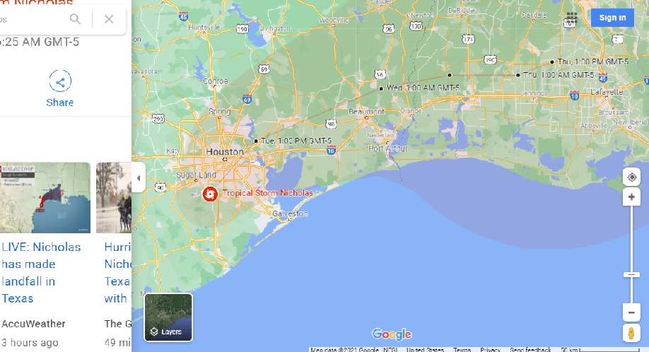
It's currently over south Houston, with (reportedly) 60mph winds and moderate rain. Probably a little East of that location by now as the last update I saw showed it at 29.30 95.30. That would be about 45 miles South of my location.
Wind has picked up substantially here and we've had rain continuously since about 1 am but nothing heavy.
|
|
|
|
Hudini
|
SEP 14, 06:23 PM
|
|
Ouch, stay safe.
Another typhoon just passed through Shanghai so I feel for you. It was not too bad 50km inland and up 15 floors though. If it floods this high we are all in big trouble.
|
|
|